


The Ebstorf Map
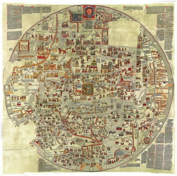
The Ebstorf Map is the largest map left from the middleages and a perfect example not only of the mappae mundi, but it showcases the impact of religion on the German/European perspective. Its origin is unknown, but it's highly likely made in the 13th century by the nuns of the ministry Ebstorf, where the map was rediscovered in 1830. After it was destroyed in an air-strike in 1943, it was recreated based on facsimiles from the 1890s, resulting in the picture below. The map is a T-O map (named after the t-shape of the combination of the Mediterranean Sea and the rivers Don and Nile, separating the world into the three continents Africa, Asia and Europe; the o-shape is based on the ocean encircling the earth - no, they did not think the world was flat), showcasing the Salvation History (Heilsgeschichte) in typical fashion of the pushed world order: the head of Christ on top (east), surrounded by paradise. The monstra of the end-times Gog and Magog (north, left side) based on a prophecy Ezekiel's to warn from the consequences of the apocalypse. Handwritten annotations explain the depicted paths, places and add descriptions to the shown monster gallery (south, right side). These monstera - not monstra (animalistic) as they are still humanoid: they have a face and therefore a soul - may have been seen as part of the miracle of god's creation (mirabilia), but were something to be feared. Some of these depictions were based on fantastic ideas, inspired by the adventures and travel stories of that time. These often had the purpose of glorifying the crusade (combined with concepts of "ere" = honour), therefore alienating different cultures by hyperbole or literal nonsense.
|